The answer is not aesthetics. For centuries, an elevated settlement made it possible to see who was approaching, defend a route, avoid river floods and keep the plain for cultivation. Hills and rocky spurs made access harder for armies, raiders and local rivals. The compact village often grew out of this combination of necessity, resources and power relations. [2]
Today, those same places may seem far from everything. Distance has changed its meaning: a climb that once offered protection can make it harder to reach a school, hospital, office or supermarket. The form of many historic villages therefore preserves two different eras: that of communities that needed to remain close together to work and defend themselves, and that of territories that must remain liveable today. [9]
A shifting word
Borgo is not an administrative category. There is no population threshold that automatically turns a municipality, hamlet or historic centre into a borgo. Treccani’s dictionary uses the term for a small or medium-sized settlement, yet the word has a wider history: its origin is linked to the fortified castle, and over time it has also referred to areas that grew outside a city’s walls. [1]
This is why borgo is now applied to very different realities. It may refer to a hilltop medieval village, a rural cluster formed along a road, a mountain hamlet, a fortified coastal settlement or a small place promoted for tourism. Some are full of everyday life, with schools, businesses and residents; others have only a few dozen inhabitants; others are busy mainly at weekends or in August. [14]
The word needs care. A common mistake is treating every small settlement as a medieval postcard. A small municipality may include newer neighbourhoods, scattered hamlets, an old centre and productive activities. A borgo can be part of a larger municipality. An abandoned cluster may be only one section of an administratively active territory. Words should help us see differences rather than erase them beneath a single label. [1]
High ground, for living
Building on high ground meant, first of all, being able to control one’s surroundings. From a hill, people could follow a valley, watch a ford, observe a trade route or warn neighbouring centres of danger. Towers and walls make sense within this geography: they were tools for managing distance, access and the movement of people, animals and goods. [2]
Security was only one part of the decision. Italian plains, especially before modern land-reclamation schemes, could be exposed to marshes, standing water, malaria, floods and sudden surges. Living a little higher allowed the best land to remain available for crops and reserved safer spots for houses, cisterns, churches and stores. Water itself had to be managed carefully: a spring, cistern or rainwater-collection system could determine the future of a small settlement. [3]
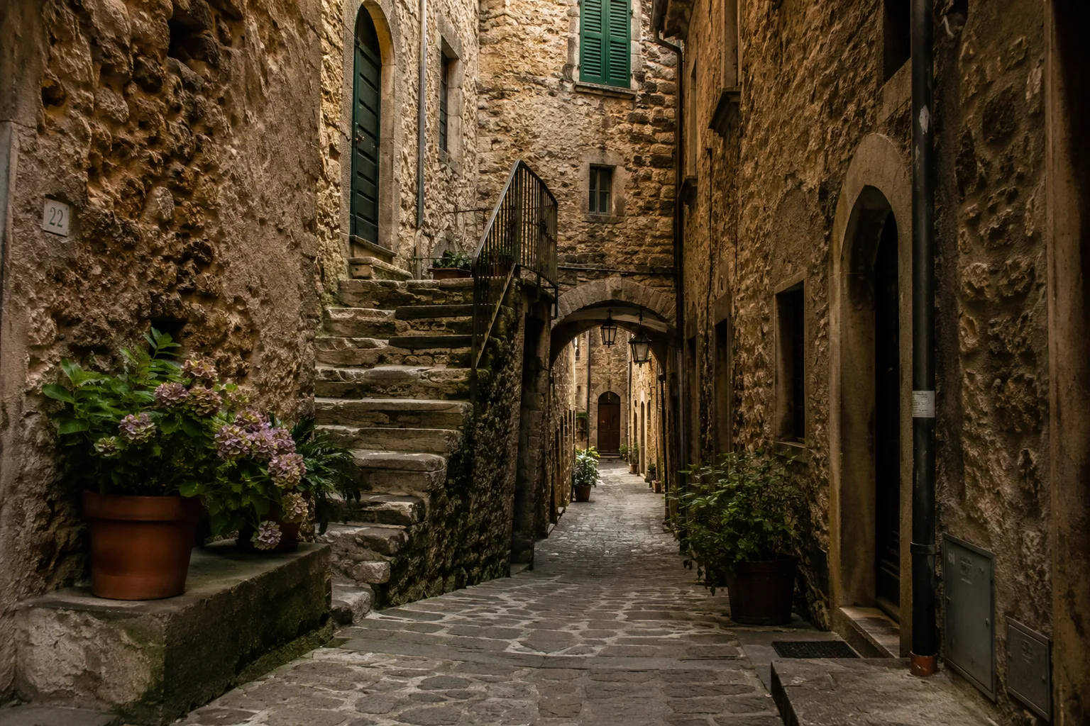
Houses pressed against one another, narrow streets and uneven building lines often result from limited space and adaptation to a slope. A ridge could not be built on like a plain. People followed the land’s form, used every available stretch, built upwards and shared walls to cut costs and heat loss. The outcome now looks striking, but it arose from practical reasons. [2]
Castles and power
Between the ninth and twelfth centuries, many rural communities in central and southern Italy, as well as elsewhere in Europe, gathered around fortifications. Historians call this process incastellamento, or castle-based settlement. People moved towards places that could be more easily controlled, built or reinforced walls, organised compact settlements and lived in closer relation to a castle, a local lord or a religious authority. [2]
Incastellamento was not simply a response to raids. Warfare and insecurity mattered, but so did control of land, tax collection, resource management and competition between noble families, abbeys, towns and regional powers. A castle could protect those living around its walls, but it could also keep watch over them: it shaped access, taxes, labour obligations and relations with the surrounding countryside. [2]
This double function remains visible in many historic centres. The castle dominates the highest point; houses descend below it; farther down stand the church, square, shops and town gates. The walls enclosed a space distinct from the territory outside. People, goods and activities concentrated within them; kitchen gardens, fields, pastureland, mills and smaller clusters lay beyond. [3]
The shape of a village tells a story of social relations as well as defensive solutions. A gate controlled entries and exits. A tower made it possible to observe and send signals. A square hosted markets, assemblies, religious celebrations and the administration of justice. Behind the stone lay a hierarchical society in which rights and obligations were distributed very unevenly. [2]
Roads, fields, monasteries
Not every Italian historic village grew around a castle. Many centres developed along Roman roads, pilgrimage routes, transhumance paths, bridges, fords and agricultural markets. A settlement might grow beside an abbey that attracted travellers, farmers, craftspeople and merchants. It might arise where a mountain road narrowed, where a valley forced passage, or where the traffic in timber, salt, wool, iron, wine and grain could be controlled. [3]
The relationship with farming was just as strong. The village concentrated homes and left productive land outside. This made it possible to live near the fields without scattering the population among isolated houses that were difficult to protect and reach. Farmers went out to kitchen gardens, vineyards, olive groves and pastureland, then returned to the built-up core. Village and countryside were not separate worlds; they belonged to the same economy. [3]
In some cases, commerce was the main function. Along a busy route, warehouses, stables, inns, bakeries and workshops could open. Elsewhere the key role was religious: monasteries and shrines offered hospitality, managed land and connected communities to wider networks. A place that now seems remote from major routes may have been a useful node in the Middle Ages or early modern period for anyone crossing a mountain or moving goods towards a port city. [3]
Stone, water, slope
A historic village has to be read beyond its restored façades. Narrow, tall houses often answer a shortage of available space. Winding lanes follow the slope, avoid excessively abrupt changes in level and make a rapid incursion from outside more difficult. Steps join different levels of the settlement. Small squares occupy places where the terrain allowed space to widen or where the main routes met. [2]
Cisterns point to another decisive element: water. In a settlement built on a hill or rocky spur, a reliable spring could be worth as much as a strong wall. Water was needed by people, animals, kitchen gardens and craft activities. That is why many villages have public fountains, shared wells, washhouses and rainwater-collection systems. A decorated fountain may look like an elegant detail; it was often essential infrastructure for collective life. [3]
Walls had a political as well as a military function. They separated those living inside from those outside, regulated trade and made it possible to control access and duties. As a settlement expanded, it could build a second ring of walls or develop an outer district along the main road. In later centuries many fortifications lost their original use, were incorporated into houses, converted into stores or demolished to open new streets. [1]
Four local forms
Italy has no single type of historic village. Pacentro, in Abruzzo, stands at around 700 metres on the slopes of the Maiella and retains the layout of a mountain centre tied to the feudal history of the Kingdom of Naples. Caldoresco Castle, the town wall and the view over the Peligna basin explain the link between high ground, territorial control and seigneurial power. The municipality notes that the place appears in sources from at least 1170 and that its fortifications were strengthened in several phases. [4]
Castelsardo, in northern Sardinia, follows a different logic. Its fortified core developed on a promontory facing the sea. The position served to control landing places, routes and stretches of coast in a Mediterranean where trade, fishing, wars and raids were constantly intertwined. The Municipality of Castelsardo dates the formation of the fortified town to the beginning of the twelfth century, when Genoa supported its foundation. [5]
Ostana, in the Cuneo Alps, offers instead an example of a polycentric mountain settlement. Its hamlets are distributed across slopes at markedly different altitudes and tell of a life based on pasture, mountain farming and seasonal movement. The municipal planning manual describes a mid-slope settlement extending from about 1,100 to 1,600 metres: a form shaped more by the mountain than by compact urban logic. [6]
Fontanellato, in the plain around Parma, reminds us that a historic village need not stand on a hill. The town is linked to natural springs, resurgences and the Rocca Sanvitale, surrounded by a moat supplied by local waters. Here, territorial control took the form of a lowland fortification close to the Via Emilia and set in fertile farmland. Local history begins with settlements long before the Middle Ages and later passes through the castle and the presence of the Sanvitale family. [7]
Connected, not cut off
For centuries, residents of a historic village were anything but cut off. Connections were slower, seasonal and vulnerable to local conditions, but they existed. Weekly markets brought villages and countryside together. Fairs drew merchants and livestock breeders. Drovers’ roads linked distant grazing areas. Pilgrimage routes carried people, money, news and objects. Sea routes connected small ports to much larger cities. [3]
A centre could have a precise role within a wider network: storing grain, producing oil, working iron, selling cheese, hosting travellers, collecting tolls or guaranteeing safe passage through a valley. Its importance did not depend only on population. It depended on location and on its ability to serve the surrounding territory. [3]
The difficulties were real. Snow, landslides, poorly maintained roads, wars, epidemics and floods could interrupt connections for weeks. That is why communities tended to develop forms of self-sufficiency: stores, communal ovens, cisterns, local production and exchange relations with neighbouring villages. Modern isolation is often different from the old kind: today distance weighs most heavily when it prevents regular access to essential services. [8]
When the countryside empties
The decline of many villages did not arrive at a single moment. Between the late nineteenth and twentieth centuries, emigration to the Americas, northern Europe and Italy’s larger cities reduced the population of many rural areas. After the Second World War, agricultural mechanisation reduced the need for farm labour; industry and services offered steadier wages in urban centres; secondary schools, universities and healthcare drew many families towards better-connected places. [9]
Italy’s inland areas are not simply mountain areas. In the national statistical classification, what matters above all is the distance and travel time needed to reach centres that offer essential services such as education, healthcare and transport. Intermediate, peripheral and ultra-peripheral municipalities make up the inland areas. In 2024 they were home to about 13.3 million people, or 22.6% of Italy’s population. [8]
Depopulation affects these territories unevenly. Istat records a sharper population loss in inland areas than in central locations and reports tougher conditions in peripheral and ultra-peripheral municipalities. Ageing makes the issue more tangible: when the number of children, young adults and families falls, it becomes harder to maintain schools, shops, public transport and nearby healthcare. [9]
Saying that “Italy’s historic villages are dying” is too broad a claim. Some have been losing residents for decades; others sustain a stable population through small businesses, high-quality farming, commuting, immigration, well-organised tourism or new ways of working. Territorial differences matter more than a general formula. A place near a medium-sized city faces different problems from a mountain village an hour and a half from the nearest hospital. [9]
Small municipalities, big differences
As of 31 December 2024, Italy had 7,896 municipalities. Of these, 69.9% had up to 5,000 inhabitants. The figure shows the country’s strong administrative fragmentation, but it does not measure the number of medieval villages or abandoned places. It includes lowland municipalities, coastal locations, Alpine valleys, islands, farming districts, urban fringes and historic centres that differ greatly from one another. [10]
A small municipality may administer a vast territory with numerous hamlets, scattered houses, woods, provincial roads and services distributed over many kilometres. It may have a compact historic centre while most of its population lives in newer areas. It may also be demographically small but economically active because of an industrial district, a major road or proximity to a town. Population figures alone say little. [10]
The measure that matters is the quality of everyday life: can people work without leaving at dawn each day? Is there a school that can be reached? A doctor, a bus, reliable internet, a shop open year-round? In those questions, the historic village stops being an image and becomes again a place where people need to be able to live continuously. [8]
Empty homes, second homes
A restored house does not automatically mean a repopulated village. In many places, homes are recovered as second homes, holiday accommodation or property investments. This can prevent buildings from collapsing and bring income to craftspeople, restaurants and local businesses. During summer, patronal festivals or long weekends, some centres fill with people again. [12]
The limitation becomes clear when village life remains seasonal. A street of restored façades may be quiet for much of the year. Without permanent residents, there are fewer customers for shops, fewer children for schools, fewer volunteers for associations and fewer people able to keep services open. Building restoration is useful, but social renewal requires work, mobility, care and daily relations. [11]
Tourism offers real opportunities. It brings visibility, restoration work, new businesses, cultural activities and a market for local products. It can also raise house prices, make the economy more fragile in low season and turn the historic centre into a group of apartments intended almost entirely for visitors. The risk is not tourism itself; it is exclusive dependence on intermittent arrivals. [12]
Beyond the postcard
The National Plan for Historic Villages, financed through the PNRR, allocated €1.020 billion to projects for cultural, social and economic regeneration. Some funds went to regional pilot projects, others to interventions in small historic villages, and further resources supported micro, small and medium-sized enterprises in selected territories. The stated aim was not only restoration, but also the revival of local activities, services and initiatives. [11]
Such investment can have substantial effects when it begins with a concrete question: which activities do residents need? A craft workshop, transport service, clinic, school, stable digital network or agricultural cooperative may matter more than a single cleaned façade. Built heritage needs care, but it truly lives when it accommodates everyday functions. [12]
Every project should also consider duration. A cultural event can attract visitors for a weekend; accommodation can create seasonal jobs; housing recovery can prevent decay. These are useful results, but they become more solid when linked to residents, local businesses, transport and permanent services. A village open only during tourist months remains more vulnerable than one able to function throughout the year. [12]
A fragile territory
Many historic villages stand precisely in places that are environmentally delicate: slopes, ridges, mountains, gorges, clay hillsides and exposed coasts. The location that once offered defence may now demand constant maintenance of roads, retaining walls, water networks, sewerage and old buildings. A historic centre cannot be maintained through a single restoration: it needs regular and costly work. [13]
ISPRA’s 2024 report on hydrogeological instability states that 94.5% of Italian municipalities are exposed to risks linked to landslides, floods, coastal erosion or avalanches. Areas of the greatest landslide hazard cover 9.5% of the national territory, while millions of people live in exposed zones. For many small places, instability is not an abstract issue: it can cut off the only access road, damage homes and make it harder for residents and businesses to remain. [13]
Safety must therefore go hand in hand with heritage protection. Buildings need strengthening, seismic risk must be reduced, water managed, fires prevented, slopes monitored and accessibility guaranteed. Preserving a tower or square without acting on water networks, connections and occupied housing means addressing only part of the problem. [13]
Living in the present
Italy’s historic villages are not the opposite of cities. They are part of the country’s urban and rural history: places shaped by difficult terrain, farming, defence, trade and local power. Some can grow; others can find a less ambitious but tangible stability; others risk a population loss that is hard to reverse. Each case needs its own reading. [9]
Staying in the present, not in an imagined past — that is the useful question for every village. It is which conditions allow a small community to remain in the present: work, schools, healthcare, mobility, digital connections, maintenance and affordable homes. A tower, a square and a narrow street may catch the eye. A family choosing to stay gives that place a far more concrete continuity. [8]
Bibliography
Discussion
Join discussion!
There are already 0 comments on this article in the forum.