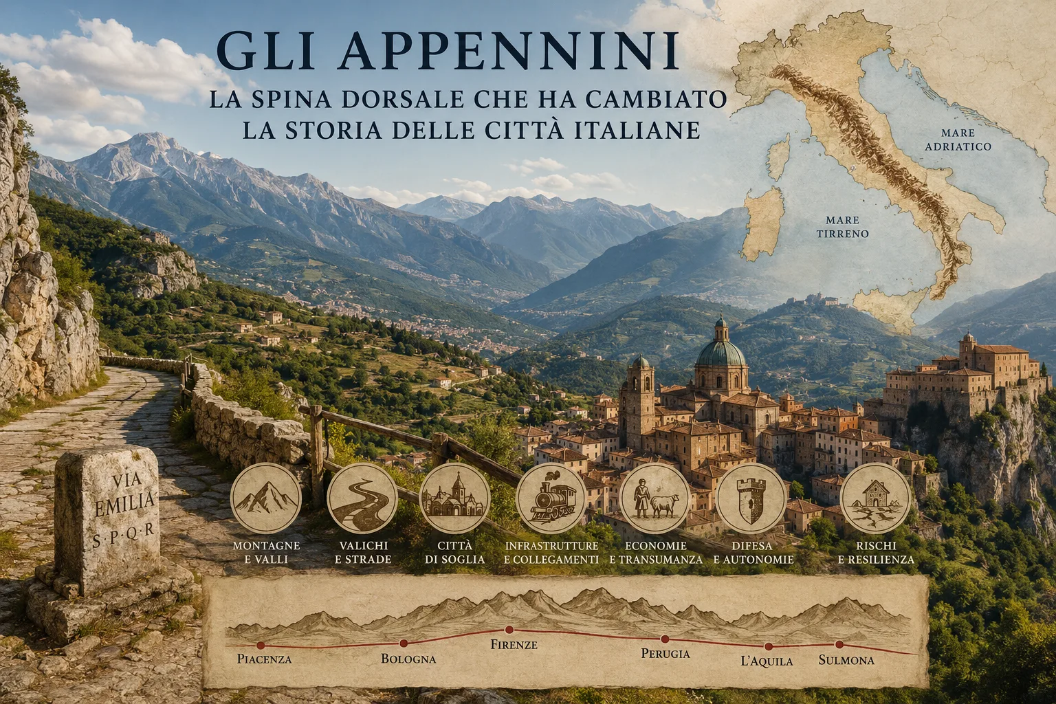
Italy is easier to understand from this physical experience. Plains played a decisive part in urban, agricultural and industrial growth, yet they cover only 23.2% of the national territory. Hills account for 41.6% and mountains for 35.2%. The peninsula is therefore chiefly a country of hills and mountains, where broad flatlands have been valuable and comparatively scarce spaces. The Apennines run along almost the whole of continental Italy, from Liguria to Calabria, and continue in Sicily in systems that differ from one another but belong to the same Mediterranean geological history. They are not a backdrop to cities: they determine where a city can expand, where a road can keep its level, where a river can become a route of communication and where a territory remains hard to reach. [1][2]
Two sides
The Apennine chain follows Italy from north to south, but its most concrete effect often concerns the relationship between one coast and the other. In many stretches, crossing the peninsula from west to east required more time and resources than travelling along the coast from north to south. The Tyrrhenian, the Adriatic and the inland areas therefore developed different networks of towns, ports, markets and connections. The mountains do not form a uniform barrier: their height, composition, width, gradient and continuity all vary. Yet they almost always impose a practical question: through which valley can one pass, by what means, in which season and towards which town? [3]
The northern Apennines make this difference particularly clear. Their ridges generally run north-west to south-east, while the drainage pattern changes from one side to the other. On the Adriatic side, transverse valleys, often directed towards the sea, are predominant. On the Tyrrhenian side there are longer basins and valley sections, including the Casentino, Mugello, Valdarno and Tiber valley. This layout set the way Tuscany, Emilia, Romagna, Umbria and the Marche built their ties with one another. A town could be well connected along a river and still awkwardly placed in relation to another centre only a few kilometres beyond the ridge. Distance as the crow flies tells us little when the land forces people to follow a valley, skirt a mountain or look for a pass that can actually be used. [2]
Threshold towns
Italian towns are not scattered at random. Many were founded or grew where local conditions made it possible to bring different territories into contact: at the meeting of rivers, at the mouth of a valley, on the edge of a plain, on a defensible hill or beside a road axis. Bologna is a particularly clear example. Its metropolitan area includes plain to the north-east and hilly, mountainous land to the south-west, cut by valleys such as those of the Reno, Savena and Santerno. For centuries the city has occupied a position of contact: it faces the Po Plain, with the Apennines and their crossing routes immediately behind it. The Via Emilia, opened by the Romans, helped turn Bononia into a road junction and linked the outlets of Apennine valleys to the urban network of the plain. [4][5]
L’Aquila tells a different geographical story. It rises on the sides of a hill above the Aterno river, at the centre of the Aquila basin. Here the city does not occupy the edge of a broad plain: it grew inside the Apennines, in an inland space able to gather communities, trade and administrative functions. Sulmona, on the southern edge of its own basin beside the Gizio, offers another example of an inland town that developed where relief, water and cultivable land could sustain a permanent centre. Perugia, too, has a connecting position: it stands on a hill in the Tiber valley, near routes linking it to Lazio, Emilia, Tuscany, the Marche and eastern Umbrian towns. These places show that the mountains produced regional hubs, not only isolated settlements. [6][7][8]
Valleys that lead
An Apennine valley can seem closed to someone looking at it from outside. For those who lived there, it could be a very clear direction of travel. Following a watercourse, one encountered fords, bridges, mills, woods, pastures, markets and villages. Valleys carried timber towards towns, wool and cheese towards the plains, people towards fairs and animals towards seasonal grazing. In some areas they linked the sea to the interior; in others they guided movement between foothill towns and ridgelines. The difficulty did not vanish, but it became manageable: anyone who knew a valley knew the timing of snow, the places prone to landslides, the springs, the stopping places and the opportunities for exchange. [2]
The Via Emilia helps make sense of this logic. It ran at the foot of the hills, between Rimini and Piacenza, where roads descending from the Apennines could meet the routes of the plain. Treccani describes it as an axis able to collect paths arriving from the mountains and connect them with those leading towards the Po and Emilia’s towns. Its route explains the long urban sequence of Emilia better than many administrative maps: Rimini, Forlì, Faenza, Imola, Bologna, Modena, Reggio Emilia, Parma and Piacenza are different towns, yet all lie close to the point where the plain meets the relief. Emilia’s urban system grew in part from this threshold position. [4]
Roads that matter
Mountain passes decided hierarchies, alliances and rivalries. A usable pass could help a town grow, attract merchants and soldiers, bring customs posts and tolls, while also exposing the area to invasions and raids. The Futa Pass linked Florence and Bologna. The Cisa Pass offered a route between Parma, Lunigiana and Liguria. The Via Flaminia connected Rome with the Adriatic through the Umbrian Apennines, while the Via Salaria crossed Sabine and Abruzzese territories through gorges, heights and valleys. The Via Valeria led towards the Fucino basin, Forca Caruso and the Aterno gorge. Every route was a technical and political choice: a road had to find sustainable gradients, water, stopping points and territories that could be controlled. [3]
Roman roads left a lasting mark, but routes do not belong to antiquity alone. Medieval roads, mule tracks, nineteenth-century railways and modern motorways often followed the same natural corridors, adapting them to the technology available. In Emilia, the historic railway network largely took up the structure of movement already mapped out by the plain and the Apennine valleys. Lines climbing towards Bologna, Florence, Parma and La Spezia had to tackle the ridge without disregarding the topography. The mountain still decides where it is sensible to pass, even when a traveller crosses it in a tunnel and no longer sees the relief. [4]
Mountain economies
For centuries the Apennines supplied essential resources to towns and nearby plains. Woodlands provided timber, charcoal and building material. Water powered mills, fulling mills and small craft activities. Summer pastures supported livestock that moved down to milder areas in the colder months. Chestnuts, cereals, pulses, upland gardens and crops adapted to slopes sustained communities that did not live outside exchange, but within often extensive economic networks. A valley could sell cheese and wool; an inland town could host markets, fairs, courts and stores; a village beside a transhumance route could live from people and animals on the move. [9]
Transhumance captures this relationship between mountain and plain particularly well. UNESCO, which inscribed it on the intangible cultural heritage list, describes it as the periodic movement of herders and their flocks between areas that differ in climate and terrain. In Italy, the droveways between Abruzzo, Molise, Campania and Puglia connected mountain districts, inland basins and southern plains for centuries. The practice plainly had an economic dimension, but it also built social ties: shepherds, breeders, craftspeople, inns, markets and rural communities took part in shared rhythms. The Apennines did not live apart from the coasts and the great plains; they sold, bought, processed and moved resources through networks that were often seasonal. [9]
Defence and autonomy
High ground encouraged many compact forms of settlement. A hill made it possible to watch over a valley, to protect oneself from floods and to see arrivals in advance. A narrow passage was easier to guard. Walls, fortified sites and hilltop villages derive in part from these material conditions. In L’Aquila’s case, its position within the basin and the history of communities scattered among villas and castles help explain why the city acquired a role of gathering and territorial organisation in the Middle Ages. The relationship with relief differs from place to place, however: a city such as Perugia uses a hill and a network of communications; an Abruzzese town has to work with basins, plateaux and valleys; centres in Irpinia, Molise, Basilicata and Calabria face more fragmented mountain systems. [6][8]
It would be too easy to attribute Italian localism to the presence of mountains. Strong local identities also have roots in medieval political fragmentation, city-states, lordships, diocesan boundaries, dialects, commercial rivalries and uneven patterns of land ownership. Geography made differences more frequent and some links more expensive. It did not write Italians’ character by itself. It created favourable conditions for a multiplication of communities, each with its own markets, institutions, cuisines, festivals and habits. Apennine towns often played a central role for dozens of surrounding municipalities, even when they remained much smaller than Rome, Milan or Naples. [5][8]
Infrastructure and risk
Railways, tunnels, state roads, motorways and viaducts have reduced some historical obstacles. They have not made the territory uniform. Modern infrastructure tends to cluster along specific axes: valley floors, coastal strips, foothill towns, motorway and rail junctions. Even when a tunnel makes it possible to cross a ridge quickly, services and economic activity do not automatically spread around it. Some centres remain close to a mobility corridor; others lie beyond the main route, perhaps only a few kilometres away as the crow flies but with much longer journey times. Apennine geography therefore still affects employment, education, healthcare and everyday travel. [4]
Earthquakes, landslides and unstable slopes add to this condition. Risk does not depend solely on the force of a natural event. The Italian Civil Protection Department describes it as the result of the interaction between hazard, vulnerability and exposure: the quality of buildings, settlement density, maintenance and planning all matter. ISPRA’s report on hydrogeological instability updates national hazard maps and notes that in 2024 areas exposed to landslide hazard covered around 69,500 square kilometres, or 23% of Italy’s territory. The figure concerns the whole country, not the Apennines alone, but it helps explain why hilly and mountainous areas require continuous maintenance of roads, slopes, woods and water systems. [10][11]
Distances today
Speaking of inner areas avoids a common simplification: mountains and remoteness do not always coincide. There are well-connected Apennine districts and lowland places far from essential services. Italy’s National Strategy for Inner Areas begins precisely with access to healthcare, education and mobility. Municipalities are assessed according to actual average road travel times to centres that provide these services. Intermediate, peripheral and ultra-peripheral municipalities together form the inner areas. Distance, then, is not measured in kilometres alone: what matters is the time needed to reach a hospital, a secondary school, a station or stable work. [12]
In 2024, around 13.3 million people lived in Italy’s inner areas, equal to 22.6% of the national population. The figure covers highly diverse territories, from Alpine districts to islands and Apennine ridges. Istat also records a worrying but uneven demographic trend: between 1951 and 2024, inner areas lost 1.4 million residents, or 9.6%, while the centres increased their population by 39.2%. In 2024 alone, inner areas declined by 0.2%, compared with a broadly stable population in the centres. A substantial share of municipalities that have declined continuously across censuses lies along the Apennine spine, though the picture remains varied and changes greatly between regions, valleys and towns. [13]
Staying and crossing
Depopulation does not by itself describe today’s Apennines. Some villages lose residents, young people and services; others find new roles through quality farming, forestry supply chains, craft work, decentralised universities, community co-operatives, walking tourism and remote work. Tourism can bring income and help recover buildings and paths. On its own, however, it does not make a territory liveable for twelve months of the year. A village full for a few weekends but without a school, doctor, public transport or continuing work remains fragile. The more useful measure is not visitor numbers, but whether a family can realistically choose to live there without giving up essential services. [12][13]
The Apennines have divided slopes and made connections more complicated, but they have also created crossings. Valleys guided rivers, roads, railways and flocks. Passes joined towns that maps show as close, yet which the mountain kept historically distant. Bologna and Florence met through the Futa; Rome and the Adriatic through the Flaminia; Abruzzese and Molisan districts through transhumance routes and inland basins; Emilia’s towns along the Via Emilia and the outlets of their valleys. Italian towns did not arise in spite of the Apennines. Many arose because they learned to live at their edges, inside their valleys or at the points where crossing was possible. [3][4]
Bibliography
Discussion
Join discussion!
There are already 0 comments on this article in the forum.